Craftpine

Program · since October 2026 · Running

Water

Cities keep the records of their water pipes in every form, from open data files to cards filled in by hand. This program puts those records on a map. It began with lead service lines, the pipes from the main into each home.
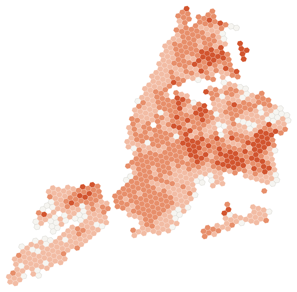
Map of New York City in 1,041 small hexagons, each shaded by the share of its service lines with lead on record. In 835 cells up to a quarter of the lines are lead on record, in 113 up to half, and in none more than half. 93 cells have no lead on record.
New York City, lead on record by area. 815,270 service lines in cells of about 0.7 square kilometres, and 117,525 of them lead on record. Cells with fewer than 10 lines are left out. From the City's Lead Service Line Location Coordinates (NYC Department of Environmental Protection, NYC Open Data, read Oct 24, 2026), counted in an area file of Nov 4, 2026. The map shows what the record says. Craftpine did not dig up, test or inspect any pipe. Open the map with both views

Live today

The address check and the area maps run on the records that cities and utilities publish. The address check shows the record for an address. The maps count the records by area.

  • 4.86 millionrecords from 9 public inventories in Canada and the US
  • 74cities and counties mapped by area
  • 3free tools that run in the browser and send a file nowhere

No model answer until a model passes

The model's release check was approved on November 3, 2026: at most 1% of “not lead” calls may be lead or galvanized pipe that needs replacing. Every run since is held to it.

No city passes today. The address check shows the record and no model answer.

  • CalgaryFails
  • NorfolkFails
  • KitchenerToo little data
  • WaterlooToo little data
Four results, all public. These are results about our model on public data. They are not findings about a city. Read the four results

Any record in

A utility's own records come as spreadsheets, GIS files, scanned cards, photos and sketches. Since November 14 the program has been building one platform that reads each kind, keeps where every value came from, and joins them into one record per pipe.

SpreadsheetsGIS filesElevation tilesScanned cards and PDFsPhotosA sketch on paperCleanedevery changeloggedOne recordper pipe, withits sourcesThe next digwith itsreasonsbuiltbeing builtplannedSpreadsheetsGIS filesElevation tilesScans and PDFsPhotosA sketch on paperCleaned, every change loggedOne record per pipe, with its sourcesThe next dig, with its reasonsbuiltbeing builtplanned
Built means written and tested, not yet hosted. The readers for spreadsheets, GIS files and elevation tiles were built by November 15, 2026. The platform is private, and nothing from it is released yet.

Built on simulated cities

Each screen is built and checked on simulated cities first. A simulated city is made from open data, with the same gaps and errors real records have. It never carries a real city's name, and every screen says it is simulated.

The aim is a screen anyone can use, with one sentence and one big button. An expert view keeps every number, source and model choice.
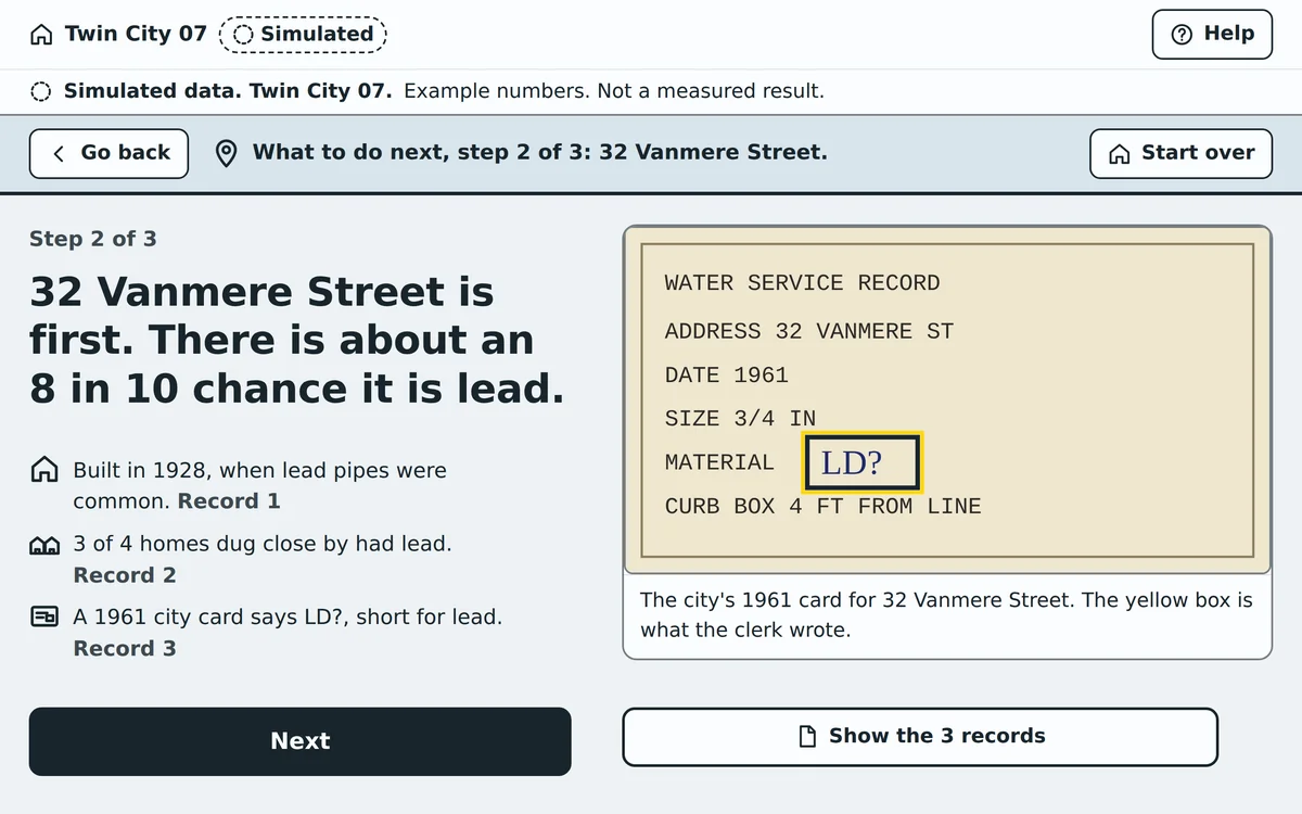
A design sample of one screen, marked Simulated, on a made-up city called Twin City 07. It reads: 32 Vanmere Street is first. There is about an 8 in 10 chance it is lead. Three reasons follow, each tied to a record, beside a 1961 city card whose material box says LD?
A design sample, November 15, 2026. One home on a made-up city, the chance its line is lead, and the record behind each reason. Every number on it is an example, not a measured result. On real cities the address check shows no model answer until a model passes the check.

Every line a water utility runs

Lead service lines come first, because the work crosses every layer: records, maps, digs and residents. The same core is planned for the rest of what a water utility runs.

  • FirstLead service lines
  • PlannedWater quality
  • PlannedWater mains and assets
  • PlannedMain breaks
  • PlannedPressure and flow
  • PlannedSewer and storm
  • PlannedLeaks
  • PlannedResidents
  • PlannedField crews
Lead service lines are the first line. The others are planned on the same core, and none is released.

Where it stands

The address check and the area maps are live. The platform is private and in build, and nothing from it is released yet.

OctNovOct 22First commitNov 3Release checkapprovedNov 14Platform buildbeginsNov 15First filereaders builtWaterrunningNov 2Address checkgoes liveNov 13Lead pipe recordsmap goes liveOctNovrunningOct 22First commitNov 2The address check goes liveNov 3The release check is approvedNov 13The lead pipe records mapgoes liveNov 14The platform build beginsNov 15The first file readers are built
Dates from the program's commits and the site's release records. A small screen marks a page that went live.